Space and Agriculture: USDA to Integrate NASA’s Earth Observation and Geospatial Analytics into the USDA Data Modernization Plan
On October 24, 2026, an agreement between NASA and the USDA was signed with the aim of improving agricultural statistics via satellite imaging, observation of the Earth from space, and geospatial analytics. Due to the USDA’s recent operational challenges, fewer farmers are participating in surveys, there is less staffing, and there has been increased doubt about the reliability of USDA acreage and yield reports, as well as their official crop forecasts.
Executive Summary
On October 24, 2026, an agreement between NASA and the USDA was signed with the aim of improving agricultural statistics via satellite imaging, observation of the Earth from space, and geospatial analytics. Due to the USDA’s recent operational challenges, fewer farmers are participating in surveys, there is less staffing, and there has been increased doubt about the reliability of USDA acreage and yield reports, as well as their official crop forecasts. This partnership could strengthen the confidence and reliability of USDA reports. However, this does not change agricultural supply. Therefore, the main impact of this deal is in improving how agricultural supply is being measured, instead of changing the supply itself.
Restoring Confidence in Agricultural Statistics
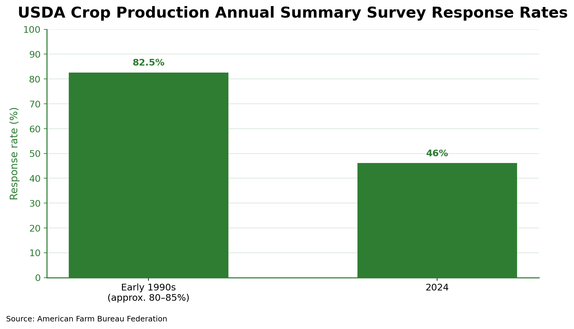
This agreement addresses increasing concerns about the reliability of the agricultural reports that the USDA writes. Farmer participation in government surveys has reportedly declined over the past decades, which reduces the information available to the National Agricultural Statistics Service (NASS). According to the Farm Bureau Federation, response rates to quarterly agricultural production surveys fell from around 80-85% in the 1990s to as low as 46% in 2024. In addition, NASS employee losses have added more pressure to data collection.
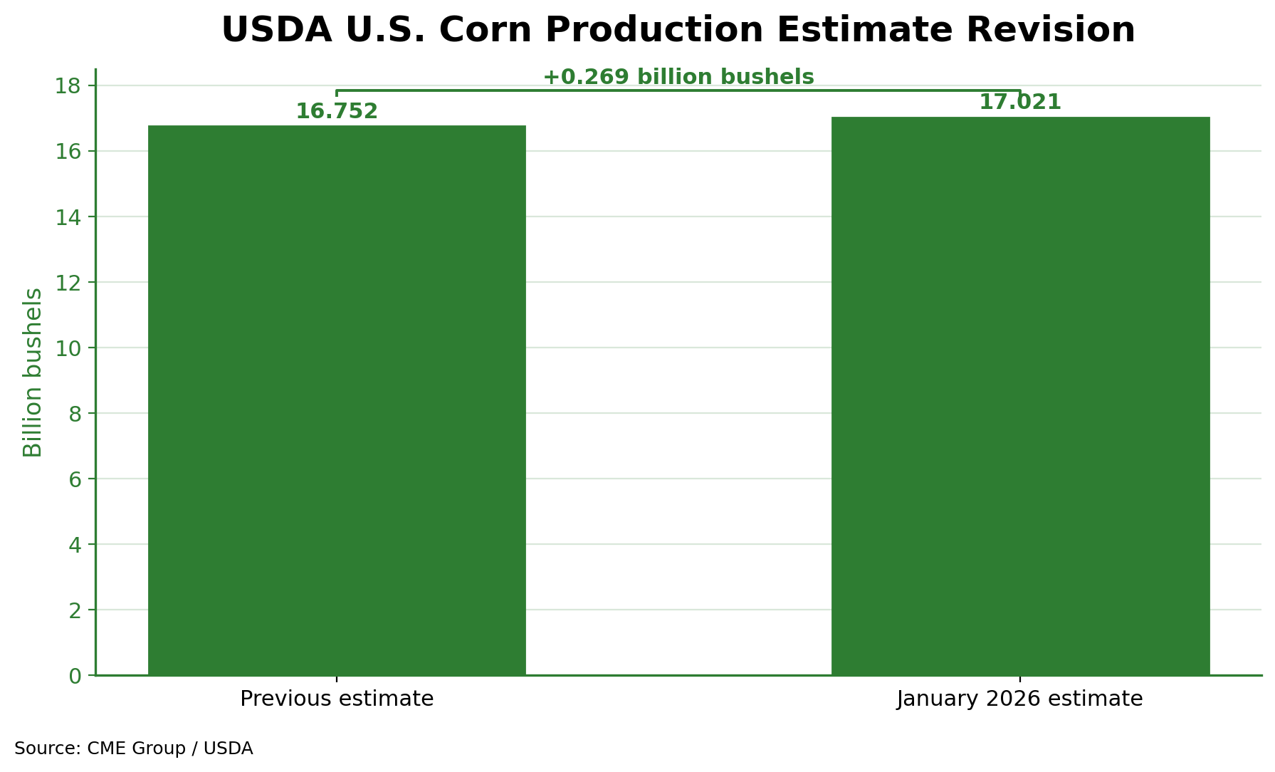
These weaknesses became even more visible in the 2025 US corn reporting cycle. In January, the USDA placed its estimate of harvested corn acreage at 91.3 million acres, which is an increase of 1.3% from its previous estimate and 5.2% higher than the June report. Because the market expected a higher corn supply, corn prices dropped by 5.4%, showing how changes in reported supply can rapidly create movements in the market.
A more recent example is a processing error that affected September 2026 corn yield estimates in Kansas and Nebraska. Here, incorrect acreage weights distorted regional and national yield calculations. Although the estimates were later corrected, the error showed that methodological weaknesses influence perceived supply and hence market pricing.
How Satellite Technology Can Improve Agricultural Forecasting
The partnership between NASA and the USDA intends to address these issues by integrating NASA’s technology, such as satellite observations, geospatial data, and statistical modeling. The cooperation is centered on aligning NASA’s Earth observation technology with USDA requirements, which can improve data access as well as infrastructure, and on developing better agricultural forecast methods.
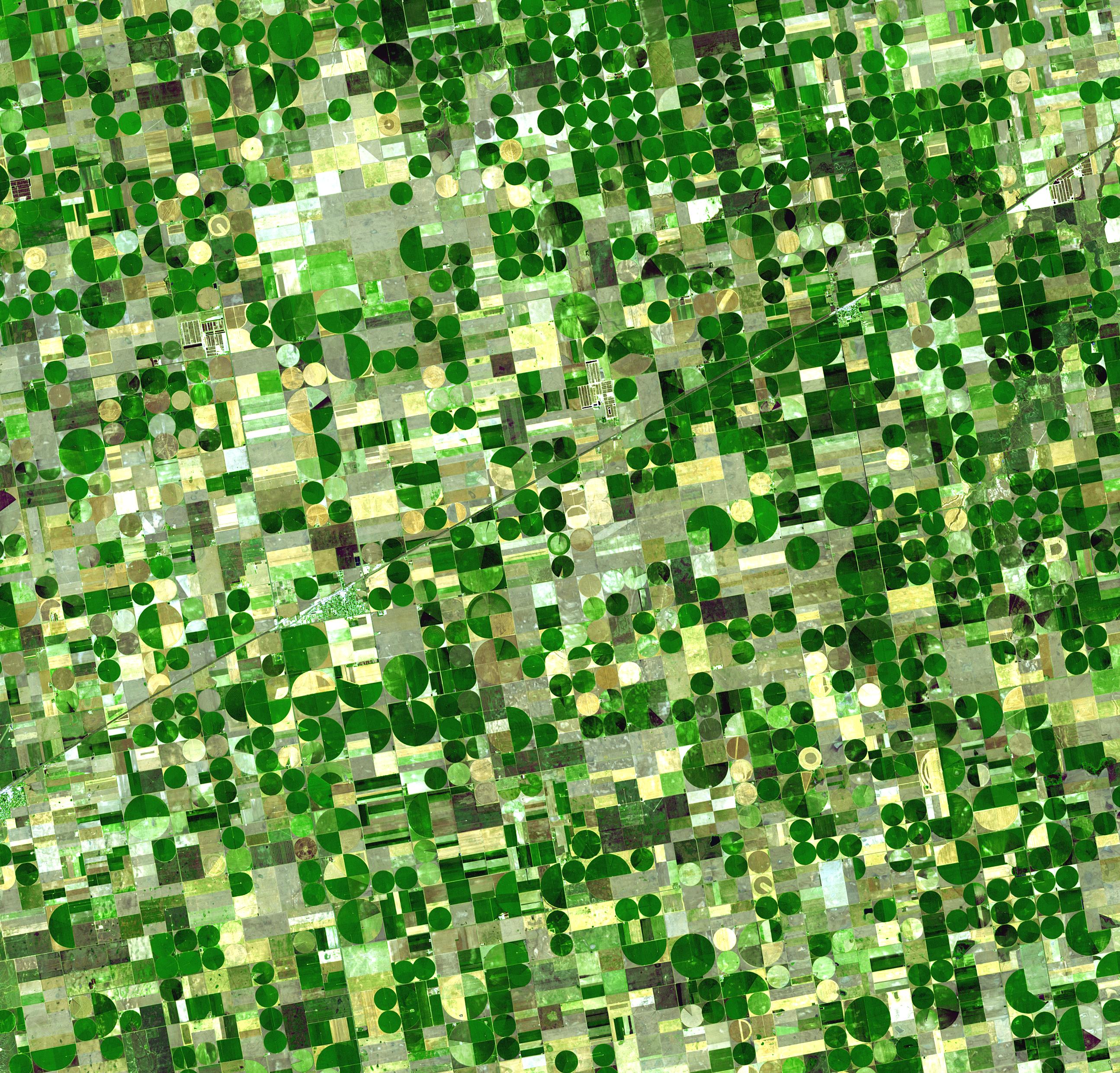
Satellite imagery can help identify planted and harvested land areas, as well as monitor crop development. NASA technology would also be suitable for monitoring drought, natural disasters, and other weather patterns. This technology can be used to combine observations with farmer surveys and crop models to create a more comprehensive and accurate depiction of agricultural conditions.
An important note is that acreage and yield are distinct components of production. While satellite imagery can help identify where crops are grown and can monitor their development, there still needs to be consistent, on-ground checks and methodologies to produce reliable production estimates.
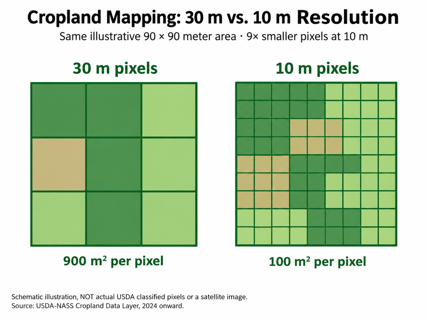
The USDA’s Data Modernization Plan (made in September 2026) supports this approach with simultaneous testing of administrative records and geospatial observations. The Cropland Data Layer recently improved from 30-meter to 10-meter resolution, showing potential for more detailed monitoring. However, the benefits of these technologies are not yet measured, as they depend on the statistical outcomes and accuracy of forecasts.
Market Expectations
Unlike a report concerning an individual commodity, this is a much more general outlook. This agreement could improve agricultural supply estimates, but it provides no evidence of an immediate change in production or inventories. Therefore, it is unlikely that we will see a directional response across agricultural markets.
Market participants are likely to focus on the implementation of these technologies and whether the partnership brings more accurate USDA forecasts and reports. More reliable estimates can reduce uncertainty and volatility, though improved measurements could also show inaccuracies in today’s forecasts.
This agreement is more likely to have an impact on long-term development rather than on short-term market prices. The quality of the data produced from this agreement (and the technologies that come with it) will determine how it is incorporated long-term.
Our Forecast
Our forecast involves looking more into longer-term implications, because there is insufficient evidence or tangibility to determine a bullish or bearish outlook for agricultural commodities here. This agreement can address structural weaknesses in agricultural reporting, eliminating or reducing the impact of unreliable statistics on agricultural market pricing. Better data can strengthen confidence in USDA reports, although it would not necessarily imply a directional change.
However, beyond just transparency, reliable forecasts can have positive implications for long-term production decisions. Confidence in USDA reports can incentivize higher survey response rates from farmers and a greater willingness among farmers to produce. Higher confidence can allow farmers to make more informed decisions regarding crop selection and scale, as well as better assessments of market conditions. However, improved information would not necessarily mean higher production in the long run. Better accuracy could improve investment and trade in agriculture, but this would be a minor change compared to other global and geopolitical factors that influence prices of different commodities.
Thesis strengthens when:
- Satellite observations give a significant improvement to acreage and yield estimates.
- Validation of predictions reduces unexpected revisions and methodological errors.
- There is improved transparency and more confidence in USDA reports.
Thesis weakens when:
- Estimates using combined technologies do not match actual ground conditions.
- Delays in implementation prevent meaningful improvements.
- Low survey completion continues to affect data collection quality.
- New methods create further errors.
Conclusion
This agreement between NASA and the USDA represents a significant step toward implementing recent and global technologies to modernize agricultural statistics. This is even more important considering that USDA reporting is under pressure. There is potential to improve how acreage and yields are measured, which can strengthen available information to global commodity markets. However, changes in agricultural commodities themselves will likely not be seen short-term, and there may be modest effects long-term. These impacts are very likely to remain limited until there is a tangible improvement in statistical accuracy. As to the potential long-term change, we maintain a cautious view without assurance of a directional forecast for global agricultural commodities.
Data Sources
- RFD-TV: USDA Secretary Rollins and NASA Administrator Isaacman Sign MOU to Advance USDA Data Modernization Plan
- New Space Economy: NASA and USDA Align Satellite Data With Agricultural Statistics
- USDA: Data Modernization Plan
- Mexico Business News: USDA to Test Satellites, AI for Crop Estimates
- NASA: NASA, USDA Sign Agreement Advancing Earth Science, Agriculture
- FreshPlaza: Record Diesel Prices Increase U.S. Harvest Costs
- RFD-TV: Corn Growers Demand Answers After USDA NASS Data Error
- American Farm Bureau Federation: Crop Report Revisions Highlight Importance of Accurate Estimates
- AgWeb: USDA Reveals Cause of Data Error That Skewed September Corn Estimates
- Rural Radio Network: Scrutiny Grows Over USDA Crop Estimates Following Major Corn Acreage Revisions